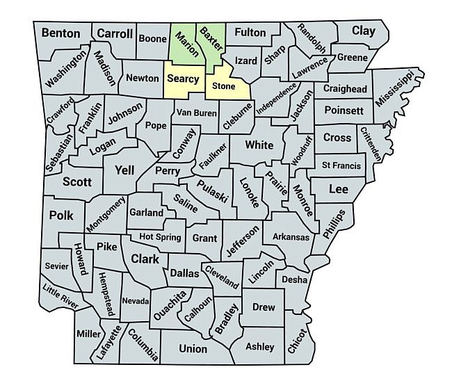
Pick a Trail – North Central Arkansas Find Trails Near You Baxter & Marion Counties Searcy & Stone Counties Baxter & Marion Counties Buffalo Point: Indian Rockhouse Trail – 3 mi Buffalo Point: Overlook Trail Loop (Buffalo River) – 1 mi Bull Shoals: Big Bluff Trail - 2 mi Bull Shoals: Dogwood Nature Trail (Corps Rec Area) - 3 mi (o&b) Bull Shoals: Lakeside Trail - 1 mi Norfork Lake: Robinson Point Trail --3 mi Rush Mine Level Trail (Buffalo River) – 3 mi (o&b) Rush Morning Star Interpretive Loop (Buffalo River) – .2 mi Rush Mountain Trail: Landing-Monte Cristo (Buffalo River) Searcy & Stone Counties Richland Creek Wilderness Waterfalls Hike (Ozark Forest) - 6 mi River View/Rock Wall Trails Loop (Tyler Bend/Buffalo River) - 4 mi Click here for all North Central Arkansas posts. Share on Facebook (Opens in new window) Facebook Share on Pinterest (Opens in new window) Pinterest Email a link to a friend (Opens in new window) Email Print (Opens in new window) Print More Share on X (Opens in new window) X Share on Reddit (Opens in new window) Reddit Share on Threads (Opens in new window) Threads Share on LinkedIn (Opens in new window) LinkedIn Share on Bluesky (Opens in new window) Bluesky
Buffalo Point: Indian Rockhouse Trail – 3 mi Buffalo Point: Overlook Trail Loop (Buffalo River) – 1 mi Bull Shoals: Big Bluff Trail - 2 mi Bull Shoals: Dogwood Nature Trail (Corps Rec Area) - 3 mi (o&b) Bull Shoals: Lakeside Trail - 1 mi Norfork Lake: Robinson Point Trail --3 mi Rush Mine Level Trail (Buffalo River) – 3 mi (o&b) Rush Morning Star Interpretive Loop (Buffalo River) – .2 mi Rush Mountain Trail: Landing-Monte Cristo (Buffalo River)
Richland Creek Wilderness Waterfalls Hike (Ozark Forest) - 6 mi River View/Rock Wall Trails Loop (Tyler Bend/Buffalo River) - 4 mi