Six Finger Falls Video (Falling Water Creek, Ozark Forest)

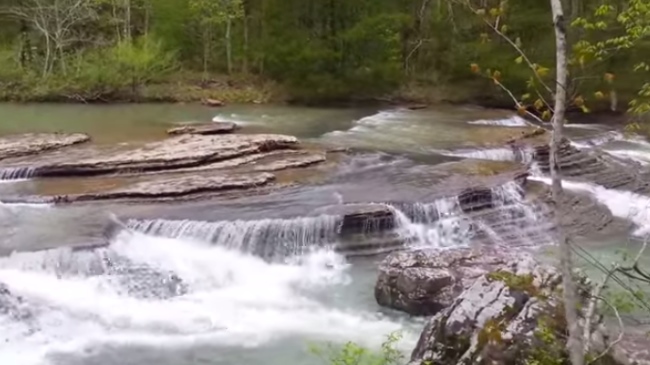
Six Finger Falls in the Ozark National Forest (southwest Searcy County, Richland Creek Wilderness) is a really cool set of cascades on Falling Water Creek, just down the road from Falling Water Falls. The falls is formed by an area where Falling Water Creek flows over six finger-like layered rock formations that span the creek. Alternate video […]

Cedar Lake Trail (Ouachita Forest) ā€“ 3 mi

[Note: Major work has been done recently at the Cedar Lake Recreation Area. Check with the Forest Service for info about trail conditions. Check here for updates.] The Cedar Lake Trail at the Cedar Lake Recreation Area in the Ouachita National Forest (LeFlore County, Oklahoma) is a pretty easy 2.8-mile loop with lots of great views of […]

White Rock Mountain Rim Trail (Ozark Forest) Fall 2014 Pics

The Rim Trail on White Rock Mountain (2,200 feet elevation) in the Ozark National Forest (Franklin County) is one of my favorite short trails. It’s only 2 miles long, but this trail has amazing views from nearly the entire trail as it circles the mountain. Check out this post for my full trail summary with […]

Petit Jean: Cedar Falls Trail ā€“ 2 mi (o&b)

Cedar Falls at Petit Jean State Park is the most impressive Arkansas waterfall I have seen. When Cedar Creek is flowing well, this is 95-foot waterfall is an amazing sight. After a visit to Cedar Falls, it is easy to see why Petit Jean was chosen to be Arkansas’s first state park. The trail to […]

Natural Dam Falls Video (Ozark Forest)

Natural Dam Falls in northern Crawford County (Ozark Forest) is a cool waterfall that is easy to get to and view. You can drive right up to the natural wall of rock that spans the width of Mountain Fork Creek. It is in the community of Natural Dam, just west of Highway 59. Alternate video link. […]

Buffalo Point: Overlook Trail Loop (Buffalo River) ā€“ 1 mi

The Overlook Trail loop (about 1.3 miles) at the Buffalo Point Campground (Buffalo National River, Marion County) is an enjoyable and not-too-challenging walk with a cool overlook of the river. The net elevation change is only about 200 feet. The trail starts at the same area as the Indian Rockhouse Trail.