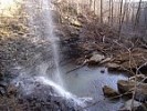
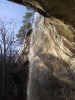
As talked about in this post, I had a nice visit to the King’s Bluff Loop Trail back in late January. Here are a few additional photographs that I took at that visit. Continue Reading »
Trails in the Ozark National Forest, Arkansas — including White Rock Mountain, Sams Throne, Pedestal Rocks, Kings Bluff Trail, Redding Spy Rock Loop Trail. Also check out this Ozark National Forest Trails Page.
As talked about in this post, I had a nice visit to the King’s Bluff Loop Trail back in late January. Here are a few additional photographs that I took at that visit. Continue Reading »
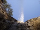
Here are a couple of cell phone videos I took of King’s Bluff Falls from my visit there back on January 28. (The second one is after the jump.) Alternate video link. Continue Reading »
The Kings Bluff Loop Trail is a 1.8-mile trail in the Pedestal Rocks Scenic Area (Ozark National Forest, northern Pope County). The elevation change on the trail is only about 350 feet. It is a pretty easy hike. There is parking and a vault toilet there at the scenic area. It is on highway 16, […] Continue Reading »
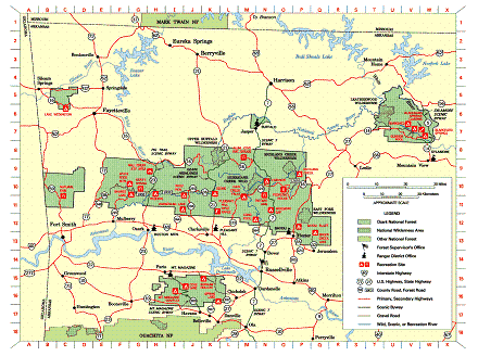
This is a helpful USFS overview map of the Ozark National Forest. It has icons indicating all the USFS recreation sites as well as National Wilderness Areas, National Scenic Areas, and district ranger offices. The version on the USFS website (here) has many clickable links. Or you can download the map as a pdf here. Continue Reading »