
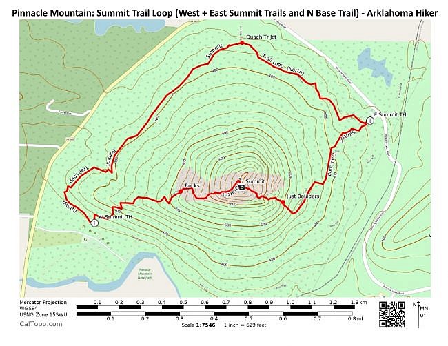
This 2.6-mile loop at Pinnacle Mountain State Park (Pulaski County near west Little Rock) takes you to the summit of Pinnacle Mountain. It includes the West Summit Trail, East Summit Trail, and the north half of the Base Trail (connecting the two summit trails).
The summit of Pinnacle Mountain is one of Arkansas’s must-see hiking destinations. It is challenging, but it is a scenic and interesting hike with amazing views.
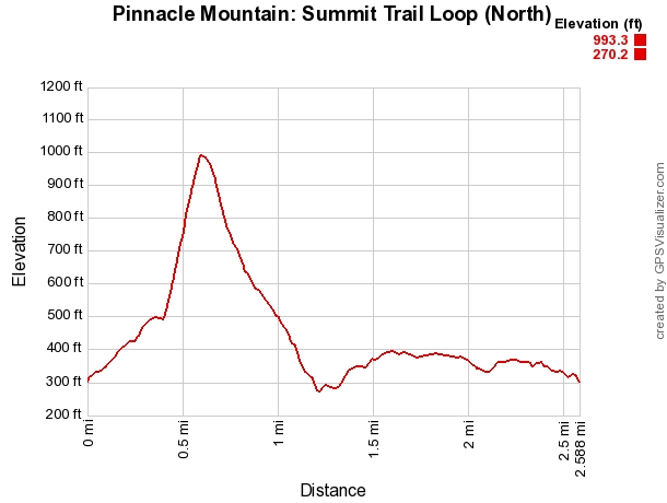
The Pinnacle Mountain summit trails are not the hardest trails in Arkansas since they are short, but they are definitely among the steepest. (Check out Mike’s elevation profile below.) In fact, guidebook writer Tim Ernst says that the East Summit Trail is the steepest trail in the state.
The elevation change from the base to the summit of Pinnacle Mountain is about 725 feet.
There is a trailhead at the base of the west side (West Summit Trail) and one at the east side (East Summit Trail). They both have parking.
The Base Trail makes a relatively level loop around the bottom of the mountain going through both trailheads.
When I recently hiked this loop, I began at the West Summit Trail trailhead and turned left onto the Base Trail. From there I hiked around the base of the mountain to the East Summit Trail. I then climbed East Summit Trail (not easily!) to the summit, and I hiked down back to my car via the West Summit Trail.


Getting to the West Summit Trailhead
To get to Pinnacle Mountain State Park from the Little Rock area, take I-430 to Exit 9, about a mile south of the Arkansas River. Head west on Cantrell Road (Highway 10).
About 2 miles west of the interstate, turn right to take Pinnacle Valley Road. Follow the signs to the park, then follow the signs to the West Summit Trail.
The Hike: Base Trail (North) to East Summit Trail
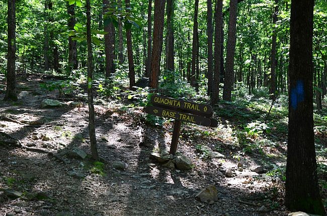
When you begin the trail from the west side you will soon (about 50 yards) come to the intersection with the Base Trail. I went left to take the north side, but you would do just as well to take the south side of the Base Trail.
The Base Trail, marked by light green blazes, has little elevation gain. (The elevation change on the entire 3-mile Base Trail is only about 100 feet.) The woods are nice and open, and the trail takes you through a wonderful stand typical of the Ouachita Mountains.
Much of the Base Trail is pretty rocky.
A little more than halfway around, the Base Trail merges with the Ouachita Trail. Stay right to continue on the Base Trail.
The Ouachita Trail (Ouachita National Recreation Trail) is 223 miles long, beginning at Talimena State Park in Oklahoma and ending at Pinnacle Mountain State Park. Its blazes are blue. So this part of the loop has blue and light green blazes.
You stay on the Base Trail for little ways longer before you come to the intersection with the East Summit Trail (to your right).

Climbing the East Summit Trail
Of the two trails to the top, the East Summit Trail is steeper and more difficult to climb.
The first .4 miles of the East Summit Trail is a steadily climbing wooded trail. After that, it is a very steep climb–mostly scaling boulders.
Climbing up the boulder part of the East Summit Trail, I often not only had to use my hands, but I had to look for places to place my feet to keep from sliding down the rocks.
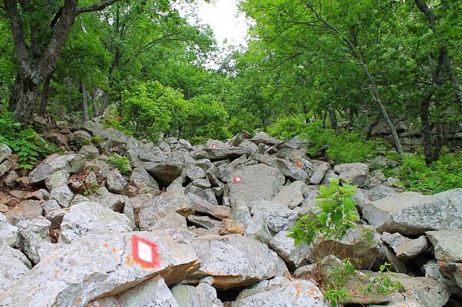
The East Summit Trail is marked with red and white blazes. I found myself varying a little from the marked path in some places. In those areas, the blazes were where the rocks were too tall or I couldn’t find a good foot hold.
Much of the higher elevation parts of the East Summit Trail has wonderful views.
At the summit, you can rest and take in 360-degree views. The summit is rocky, but it’s mostly level so your thighs get a rest.
You can walk the ridge line on the summit to the north and south. Be sure to take in the views of Lake Maumelle, the Arkansas River, and downtown Little Rock.

Heading Down the West Summit Trail
To complete the loop, take the West Summit Trail (yellow blazes) back down the mountain.
The West Summit Trail is similar to the east one in that the lower part is a wooded uphill climb while the upper part is quite steep with just rocks and boulders. But while the high part of the East Summit Trail is just scaling boulders, the upper West Summit Trail is like a steep crooked staircase.
But even on the West Summit Trail, I find myself using my hands for stability or to pull myself up on a rock.

Keep in mind that due to the balance and navigation required, going down the steep parts of these trails can be almost as hard as climbing up them. For some, it is harder.

About one-third of the way down, you leave the boulder field to a nice wide path. From there, it is fairly easy walking back down to the parking lot.
The West Summit Trail is the more popular of the two summit trails. (I have been on it a number of times.) And with it being so close to Little Rock, it can get a bit crowded.

Final Notes
Be sure to bring plenty of water. And don’t forget some for your pup if you are hiking with a dog (leash required). There are no water crossings for you dog to drink from, and there is little shade at the top.
Each summit trail is about .6 miles long. The north half of the Base Trail is about 1.4 miles long.
Of course, you can also make a loop out of the south half of the Base Trail. Taking the south half of the Base Trail ends up being about .1 miles shorter.
Mike’s elevation profile below does the (north) loop starting at the East Summit Trail.

These photos (except for Mike’s East Summit Trail pic) are from hikes I took on June 19, 2017, February 14, 2016, and January 25, 2010.

[While at Pinnacle Mountain State Park, you might want to also check out the Base Trail or the Rocky Valley/East Quarry Trail Hike.]
Photo Gallery
Click below for full-screen photo gallery.
Map
Pinnacle Mountain: Summit Trail Loop (East and West Summit Trails and N. Base Trail) | |
|---|---|
| Location | Pinnacle Mountain State Park, Pulaski County, Arkansas |
| Length/Type | 2.6 mile loop |
| Difficulty | Very strenuous (5 of 5) |
| Gpx file (by Mike) | Link |
| Date Hiked | June 19, 2017 |
| Directions | Google Maps Directions to West Summit Trailhead Google Maps Directions to East Summit Trailhead |
| Official Info (Links) | 501.868.5806 Website Park Trail Flyer (pdf) |
[A version of this post was originally published on July 20, 2017 in the blog “Right Kind of Lost.”]
[Last revised: 5-16-2021.]


