Yesterday, we took the opportunity to spend the afternoon hiking one of the many hiking loops at Pea Ridge National Military Park in Pea Ridge, Arkansas. It was a nice day for a hike with temperatures reaching close to 40 degrees.
There was still some snow on the ground from the recent snowfall, but by the time we made it back to our car, it was really beginning to melt off.
The battle of Pea Ridge was in March of 1862 and was a pivotal battle in the Civil War, keeping Missouri in the Union. The park covers 4,330 acres and has a tour road with 10 stops along the way. Each stop has a parking area and historical information about the battle of Pea Ridge. We skipped a lot of the tour and headed straight for stop 7, which is the East Overlook.
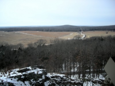
The East Overlook has a great view of the battlefields. It also looks down into rocky outcroppings that are interesting although, as the information indicated, not very good hiding places in a battle. In the picture above, you can see the battlefields and the Boston Mountains in the distance.
Leaving the East Overlook, we hiked east toward the Elkhorn Tavern. The trail followed along the bluff line, and there were great views down into the outcroppings below. There were also a lot of deer tracks in the snow and muddy places.
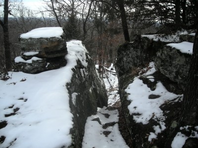
As the trail came down off of the bluff, it circled around and traveled underneath the area we had just walked, giving an entirely different perspective. One of my favorite parts of the trail was the passage through two of the rocky outcroppings. Water erosion had bored small holes through the rocks and made them very interesting. I thought it was neat to travel through the big outcropping like that, and I could certainly understand why getting caught in the middle of them during a battle would be a bad thing.
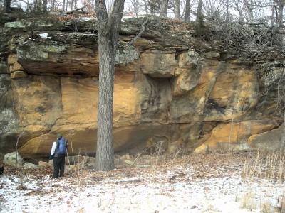
Just past this point, there were some really interesting sandstone features. We had hiked along the top of this ridge earlier, and I had no idea this was what was underneath. The ground was littered with large chunks of rock that had fallen off. The sandstone was marked with erosion patterns that were very interesting. It was certainly worth looking around the corner, and I am glad we saw it on the way down the trail.
One thing that struck me as we hiked down the trail was the abundance of wildlife. There were several different kinds of birds flying about.
Also, because of the wet ground and remaining snow, there was evidence of all types of critters making their way around the park. I was hoping we would spot some deer, as it seems that there were several deer tracks that we came across. But we were not the stealthiest group to ever hike a trail.
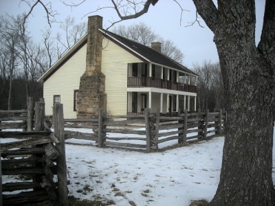
After about a half mile, we came to the reconstructed Elkhorn Tavern. The tavern served travelers on the Telegraph Road before the war came to Arkansas. It changed hands between the Union and the Confederates several times, serving as a supply base, a hospital, and a military telegraph station until Confederate guerrillas burned it in 1863. This was where we realized we had lost the map, but decided to carry on and try to figure out where we were going next using only our wits. (This time, it was not me who lost the map, but it very easily could have been.)
We hiked on and shortly made the decision to turn back to the right, which took us past the Confederate Sunset site. This was not the way we originally intended to go, but it was a nice trip anyway. The trail was fairly level and went through the woods along one of the battlefields. The trail made a circle back to the Elkhorn Tavern.
The only disappointment was that about a third of the trail followed close enough to Highway 62 for the sound of the vehicles to carry to us. A couple of times, the cars traveling the highway were visible.
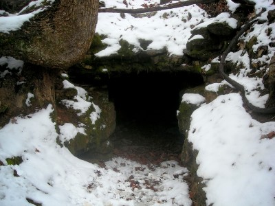
We wandered around the trails and uncovered a neat spot that had a cave and a spring nearby. The cave was fairly good-sized, and there was a crevice that led further back. Since we did not have our flashlight with us, we declined to investigate further. Next time, I’m going back to the back of the cave.
By this time, it was about 3:30 in the afternoon, and the park closes at 5. We headed back to the car, dried off the dogs, and set off down the tour road back towards home. On our way, we got to see a lot of the area we had hiked.
Then we were surprised by a large group of deer just to the side of the car. We stopped to take a few pictures and watch the deer, about 10 in all, before leaving for the day.
[This post was originally published on January 23, 2011 on “A Hiking We Will Go.”]
VITAL INFO | |
|---|---|
| Trail Name and Location | Pea Ridge National Military Park - Williams Hollow Trail |
| County, State | Benton County, Arkansas |
| Date Hiked | 2011-01-22 |
| Weather/Conditions | Upper 30's and sunny |
| Directions | I started at the Overlook. To get there, Take US 71 south until the Pea Ridge Exit and then go left on AR 72. At the town of Pea Ridge follow 72 to US 62. Turn left on US 62 to the Park. |
| Hike Length/Type | 4 miles |
| Other Permitted Usage | |
| Difficulty (1=Easy; 5=Most Difficult) | 1 |
| ATT Cell Coverage? | Partially (About 40%) |
| Official Info - Phone/Links | 479-451-8122 Website. Park map (pdf). |
